The Koworowal Walk gets its name from the Bandicoot that lives around the southern areas of Munibung Hill. Secretive little mammals we know of their presence by the many diggings or mounds of soil that they make while foraging for roots or building their shelters where they rest during daylight hours before coming out at night. They are what is referred to as ‘ecosystem engineers’ since they aerate the soil, help with water absorption and building soil fertility. Like the Wombats that we believe would also have lived at Munibung Hill many years ago, they can suffer at the mouths of predators such as cats and foxes. So please be a part of our conservation effort by keeping cats indoors at all times and reporting cats – domestic and feral – that are on the loose – predating on baby native animals when they are most vulnerable.
Featured image courtesy Bob Todd

Now for a bonus, try the Southern Loop Walk Duration: 90-120 minutes, or longer if you choose to amble and look around , 2.4 km round trip
This is one of the more popular circuits at Munibung Hill. It’s a combination walk adding three walks into one. Ridgelines, valleys, steep slopes. This walk has it all. The track takes in three Lookout points, providing one of the best overall selections of Munibung Hill vegetation including ecologically endangered communities. This is catchment country with more than 15 creek catchments located to the east and west. Except for Hawkins Creek and Munibung Creek, the rest are un-named, which is something that’s on our agenda to rectify.

Custom maps courtesy David Bretreger
Wonta, in Awabakal language means: where is this place? (1)
North side: Enter from Lawson Road at the access gate next to number 65;
South-West side: Enter from Quarry Road, Speers Point.
A third option would be Farm Street, Speers Point (Cnr Atkin Ave)
NOTE: A random internet search for Munibung Hill – which can be accessed from locations on the north, south, east and west – without providing more details, will most likely present a rather confusing map compared with the directions supplied here. When using a search engine such as Google maps it helps to specify an address, or at least a street name such as one listed here.
(1) Source: An Australian Language as Spoken by the Awabakal, L. E. Threlkeld. 1892
There are no toilets, no picnic facilities and no disposal or recycling bins. The nearest are at Cardiff, Warners Bay, Speers Point and Boolaroo.
 Dogs on leashes only. No trail bikes. Please carry out what you carry in – don’t rubbish Munibung Hill. If you come across what other people have disposed of, consider picking it up and disposing of it thoughtfully. Help us care for the habitat of local native plants and animals. Thank you.
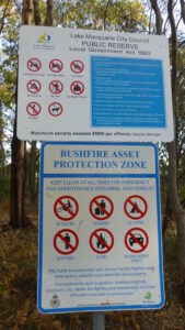
<< No signage other than Council and NSW Rural Fire Service notices. Please observe these messages and bring them to the attention of others.
There are no official car parks at the start of tracks, it is therefore important to respect the residents who live in close proximity to these areas.
When driving around Munibung Hill at night remember we are sharing the roads with our native wildlife, so take it slow and watch out for animals on the road.
For your safety and personal care, even for a short walk on a fine day, carry a light pack with a weatherproof jacket, water (1 litre per person for every 3 hours of walking), some high energy food and a first aid kit. Wear sturdy shoes or boots, a sunhat, sunglasses, sunscreen. Insect repellent can also make your walk more comfortable and be sure to take a bag to carry any rubbish out with you.